Showing posts with label Nature Photography. Show all posts

29 January 2019

South Island Tour


Tell me about a complicated man.
Muse, tell me how he wandered and was lost
when he had wrecked the holy town of Troy,
and where he went, and who he met,
the pain he suffered in the storms at sea.
- Homer The Odyssey (modern translation)


The road to Mt Cook.


We have just returned from another epic Highstead adventure. Sixteen days of driving, tramping, and camping on the South Island. The trip was undertaken during the height of summer holidays and tourist season around here, so we designed our route to avoid the crowds as much as possible. In total, we covered a little over 3,400 km (2,100 mi), almost entirely on minor highways and roadways. A surprising amount of it was on unsealed/gravel roads. Along the way, we stayed in a mixture of small baches/cribs intermingled with a lot of tent camping. Despite the huge crowds out at this time of year, we felt like we had the roads mostly to ourselves.

Most people touring the South Island are a little limited in their choice of route. There are only a few places to pick up a hire car or campervan, and the most popular seems to be Christchurch. From there, the most common route is to head north and do a big anti-clockwise loop. We were fortunate to be arriving into Picton by ferry and knew we could start in either direction. Additionally, we had already spent time in Christchurch/Akaroa (Link: Moving Pictures & Signals) as well as in Dunedin (Link: Summertime & One Tonne) and Oamaru (Link: Steampunk'd), so we could skip the southeast coast. In the end, our route took us clockwise from Picton to Kaikoura, then inland to the Rakaia Gorge and onto Mt Cook. From there, we jumped down to the Catlins, bypassed Invercargill, and headed for the Fjordlands. We finished our trip on the West Coast. Camping and sleeping in a tent meant that we had no schedule and nowhere to be. We could drive as far as we wanted, pitch our tent, and explore the local area. Every few nights, we stayed in a bach/crib so we could dry out, shower, and do some laundry.


Day 1-2 - Palmy to Wellington, Picton to Kaikoura

Loading the ferry - Wellington to Picton.


Te Moana-o-Raukawa is the tempestuous strip of water that separates New Zealand's South and North Islands. The English name is Cook Strait, and it is considered one of the most dangerous and unpredictable bodies of water in the world. The narrowest part of the strait is only 22 km wide, but the ferry crossing between Wellington and Picton takes about 3.5 hours. On the South Island, the section through Marlborough Sounds is one of the most scenic and dramatic that I have ever experienced. This would be my 5th crossing, and the ferry was packed, so we claimed some space, stayed below, and camped out for the journey. Despite the strait’s terrible reputation, I have never experienced a difficult crossing, but JRH did on her way to school camp a couple of years ago. Their crossing was so rough that cars slid around on deck and smashed into each other.

Picton to Kaikoura is another 2 hour drive, making for a lot of sitting/driving on our first day of travel. The original plan for our trip was to limit driving to only 3-4 hours each day. We wanted to explore the South Island, not zoom through it. Unfortunately, there was no way to avoid a couple of long days. Fortunately, we couldn't check into our bach until after 5p, so we weren't in much of a hurry. This time of year, the sun rises at about 5:30 and doesn't set until after 9:30p, giving us plenty of light well into the evening. Unfortunately, the weather didn't cooperate (skies were grey and overcast) and much worse, we lost our Lonely Planet guide, so we didn't take any side trips or detours. Our goal was lunch at Nin's Bin ... a roadside trailer serving what is reportedly some of the best local seafood. Seating is outside only and it was raining. We weren't prepared to brave "liquid sunshine" on our first day, so we passed it by. We had 15 days of outdoors adventures planned, and particularly on the west coast where it rains 200+ days each year, doing things in the rain would become a theme ... just not on Day 1.


Te Ahi Kaikoura a Tama ki te Rangi (Kaikoura) was established in 1853 as a whaling station, and it's name means "Meal of Crayfish" (crayfish here being what the rest of us call spiny lobster). Crayfish is on the menu all over town, but some of the best food here is at roadside trucks/trailers. Since we missed out on Nin's Bin on Day 1, the next day saw us picking up the slack at Kaikoura Seafood BBQ. Like anywhere else in the world, crayfish/lobster here is crazy expensive and JRH was shocked when she saw the sticker price on the tail we ate for lunch. She doesn't eat seafood, so couldn't experience for herself how each bite was worth every penny.

On 14 November 2016, there was a magnitude 7.8 earthquake centred approximately 60 km south-west of Kaikoura. The quake occurred at a depth of only 15 km, involved 6 different fault lines, and was comprised of two separate but concurrent events. I went into a lot of detail regarding the science and our experience here. Suffice it to say that it was a life-changing event for both Kari and me. While we felt quite a rumble 150 km away, the local results were devastating. New Zealand sits on the Ring of Fire, one of the most geologically active areas in the world, and the seabed surrounding Kaikoura has been rising at a rate of a few mm per year, but the Kaikoura earthquake instantly raised the seabed 0.5-2 metres. It completely changed the landscape, altering reefs, fisheries, and fur seal colonies. In addition, nearly 200 km of road was damaged along with an equal amount of rail line. Opening the only major roadway into Kaikoura took a little more than a year, required over 2 million work hours, and came at a cost of over $1.1 billion.


Kaikoura's alien landscape.


One of the things we have discovered on our travels is that you just can’t do it all. Everywhere we go, there is so much to see and do but just not enough time to fit it all in. Our strategy is to identify a bunch of things we would like to do, then each of us gets to pick one thing that we absolutely will do. For this trip, my choice was sea kayaking. Up and down the coastline there are dozens of places to put a kayak in and go for a paddle ... and plenty of companies willing to take your money to see it all happen. Unfortunately, for most of them, JRH was not old enough. In Kaikoura, though, we found one that was more “family friendly”. We chose the morning paddle hoping for better weather and we weren’t disappointed.

Once they got us all to the put-in and gave us a safety briefing (in the event of an earthquake or tsunami, paddle further out to sea to deeper water!), we were on our way. With the size of our group, they split us into two, so the three of us were lucky to have our own private guide. She got us right up close to some seals and let us paddle out into the ocean swells. Maria was awesome and I can’t say enough great things about Kaikoura Kayaks.


On the water with Kaikoura Kayaks.


Shoreline exploring.


Summer in these latitudes means long days with loads of sunlight. After our paddle, we had time for lunch followed by a long tramp along the shoreline then back along the cliffs. That still left us plenty of time to get back to our bach, shower, and head out for some sunset views and a late dinner. All in all, it was a great start to our long holiday.


Stay tuned, there's more to come ...

10 October 2018

Kapiti Island


Ka tito au
Ka tito au
Ka tito au ki a Kupe 
Te tangata
Nana i topetope tu wenua
Tu ke Kapiti 
- Te Rauparaha (1847), composed during his imprisonment aboard HMS Calliope


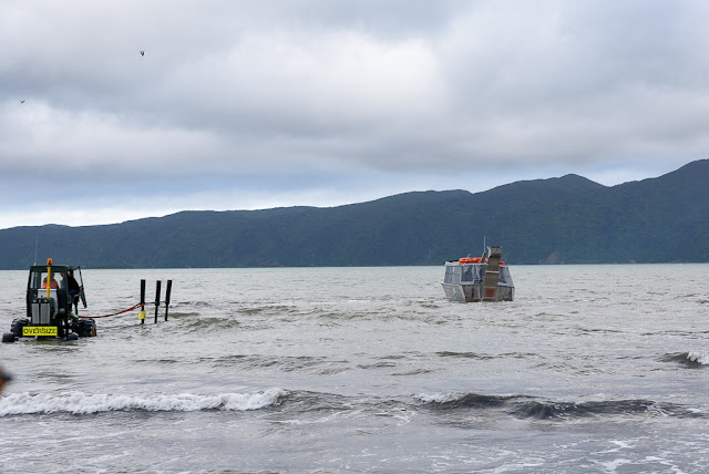
Private boat ramps on Waiorua Bay, Kapiti Island.  Photo: RGH


Driving to and from Wellington along the Kapiti Coast, when looking seaward the horizon is dominated by a large island. Kapiti Island sits just far enough offshore to appear perpetually verdant, mysterious, and unoccupied. Always looking for new places to explore, Kari discovered that it is an ecological reserve and is accessible for day trips and overnight stays. The island boasts an abundance of native plants and endemic birds, including the elusive Little Spotted Kiwi. It is one of the few places in New Zealand where one has a good chance of spotting a Kiwi (bird) in its native habitat. During our previous year here, Kari wanted to venture across Rau O Te Rangi channel and visit the island, but it was only after returning here permanently a few months ago that we were finally able to do so.

The island covers almost 20 sq km (8 sq mi), only a tiny portion of which is accessible for tramping. Almost the entirety is closed to the casual visitor and is set aside as a wildlife sanctuary. There is a limit to the number of visitors each day (100 to Rangatira, 60 to the North end). Interestingly, 13 hectares (32 acres) is privately owned by members of the Ngati Toa, Te Āti Awa, and Ngāti Raukawa Confederation. Many of them are whanau descended from an extraordinary woman, Utauta Webber, who refused to give up her land despite relentless government pressure to do so. One hundred twenty-one years after the Kapiti Island Reserve Act was established, whanau continue to live and work on Kapiti.


Paraparaumu to Kapiti Island.  Photos: RGH


John Barrett and Amo Barrett, Utauta Webber's grandchildren, established Kapiti Island Nature Tours by renovating the family bach and offering a unique homestay to visitors. Manaaki Barrett, John’s son and our host/guide for the weekend, grew up visiting the island and is now slowly assuming more responsibility for the daily operations of the business. It is truly a whanau affair, structured so that as many whanau as possible can be sustainably employed and maintain ties to their ancestral lands. Maori was not initially a written language and their history was kept alive through oral story-telling. We were captivated by Manaaki’s ability to narrate the history of his whanau and iwi, and deftly weave it into their story today.


Kapiti Island Nature Tours.  Photos: RGH & KAH


Utauta’s great grandfather, Te Rangihiroa, accompanied Te Rauparaha when Ngati Toa first seized the island in the 1820s. They successfully defended their occupation in the Battle of Waiorua (1824) when multiple iwi allied against them and tried to push them off. For Ngati Toa, Kapiti Island became a fortress and base from which to trade and launch marauding attacks. Ngati Toa developed trading relationships with whalers and fishermen from Europe and the Americas, encouraging them to live amongst them and accept Maori custom. Some married Maori women and were adopted into the tribe. As their cultures clashed, strife occasionally devolved into violence. In his book Kapiti, Chris Maclean describes Kapiti in the 1830s as “a wild frontier, a meeting point of two cultures without the restraints of law or government.” By the 1830s, the British had begun to establish a more consistent presence in the region, first sending HMS Zebra in 1833, then HMS Rattlesnack in 1838. The Treaty of Waitangi (1840) established British sovereignty in New Zealand and coincided with the decline of whaling in and around Kapiti. Whaling gave way to farming as a way of life, which only hastened the loss of native species.


Tramping through the nature reserve.  Photos: RGH & KAH


Tuteremoana summit and Western cliffs overlook.  Photos: KAH


Like much of the world, New Zealand has suffered the scourge of introduced species. Prior to the capture of Kapiti Island by Ngati Toa, the human impact would have been limited to subsistence living, supported by the abundant marine life and bird species, bouyed by limited cultivation of kumara. After their occupation, the population swelled to over 1000 people and new areas were cleared for food crops. The easiest way to clear land was by burning. Occasionally, controlled burns became wildfires that swept the island. New Zealand plants and birds evolved in relative isolation, free from predators and grazing mammals. Cattle, goats, sheep, and possum were introduced by European visitors to the island, and pests such as stoats and rats established substantial colonies. The introduction of these species proved devastating. When the island became a reserve in 1897, native plants and bird populations were finally able to begin a slow regeneration.


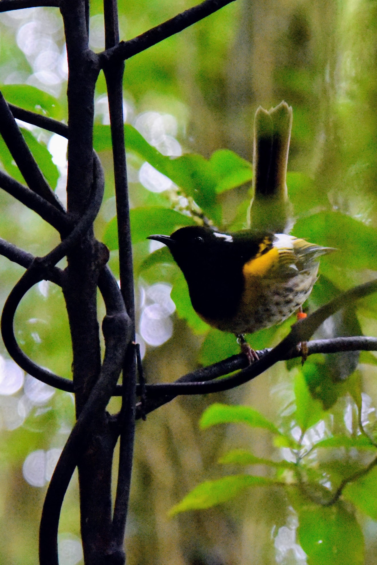
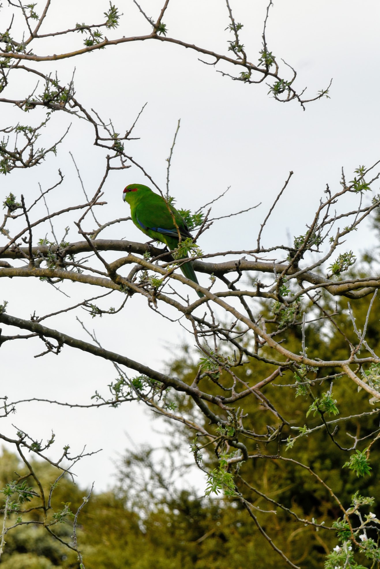
Hihi & Kakariki.  Photos: KAH

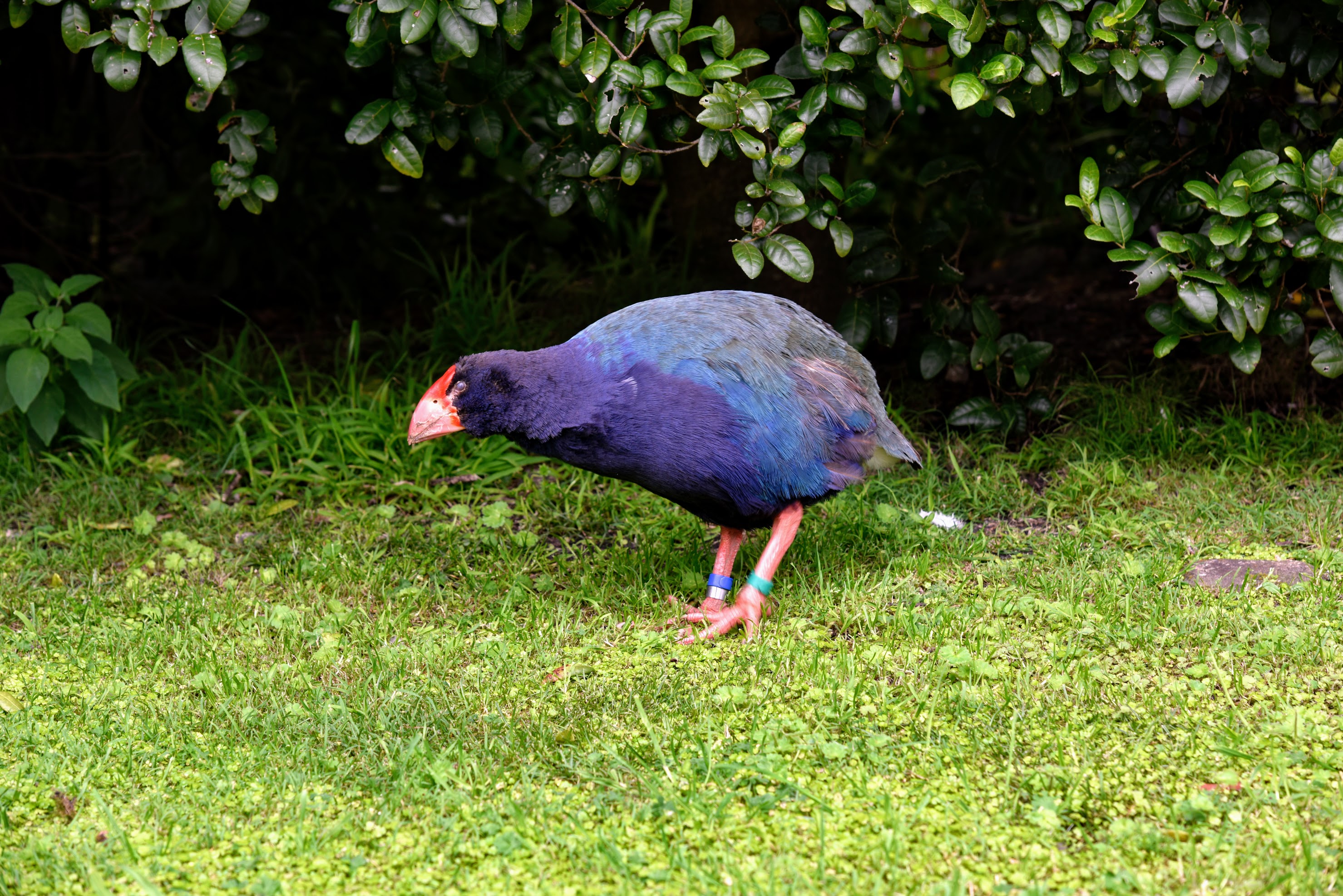
Takahe.  Photo: KAH

Kereru.   Photo: KAH

  
Kaka.   Photos: RGH


By 1917, a campaign to clear the island of grazing mammals and predatory pests had begun, but  limited farming continued on the island into the 1950s. It would take almost 80 years before the last rat, and last mammalian pest, would be cleared from the island and endemic species could flourish. Visiting the island today, it is the abundance and variety of native birds that are most impressive. Supported by the regeneration of native plant species, some have rebounded from in-place populations, while others have had to be re-introduced. This concerted effort to restore native bird species, with Kapiti Island acting as a “life raft”, has been so successful that some are transplanted from the island to bolster or re-establish populations elsewhere in New Zealand.


Sunrise over Waiorua Bay.   Photo: RGH

Manuka & view of Northern shore from Western cliffs.  Photos: KAH


Kapiti Island is one of the few areas where you might chance to see a Kiwi bird in the wild. "Might chance" is a bit of a misnomer ... we set out late at night with Wayne, one of the year-round residents, in search of these hard-to-find birds. Kapiti Island is far enough from the mainland that there is little light pollution, and it was a cloudy, nearly moonless night. More than once, I bumped into the person in front of me when they stopped abruptly. Using a light shrouded with red cellophane, Wayne crawled around on his belly looking into the dense underbrush. There were 13 of us split into two groups, and ours was the only one to actually spy a Little Spotted Kiwi in the bush. Admittedly, it was a bit anti-climactic, but it was pretty awesome none-the-less.


One of New Zealand's many great small breweries.


The next morning, the skies were clear and the sun was shining. We opted to take the afternoon boat back across Rau O Te Rangi channel, giving us a chance for a morning tramp to the top of the Western cliffs. After lunch, we set out on a guided tour of the Northern shoreline and bird nesting area. We thought we would be a little late getting to the boat landing, but were there in plenty of time to sit for a spell. Once across to the mainland, we stopped to slake our thirst and eat our fill of pizza at the Tuatara Brewery, then it was on to home.


Rats ...


02 October 2017

Green Acres


Start spreading the news
You're leaving today (tell him, friend)
I want to be a part of it, New York, New York
Your vagabond shoes
They are longing to stray
And steps around the heart of it, New York, New York
- Green/Camden/Bernstein, New York, New York


Times Square is hopping, day and night. Photos RGH


New York City, USA and we are staying in the heart of the Big Apple. We had a relatively uneventful flight across the Atlantic Ocean, landing at JFK airport and sailing through customs and immigration. After being gone for a year and travelling for a month, I anticipated a long and drawn out process, but we made it through long before our bags made it to the carousel. We arrived in the evening and all we wanted to do was get into the city in time to eat at John's Pizza in Times Square. Signs all over the airport tell people not to accept rides from solicitors, but the taxi stand was a hike and the line was long, so we made a rookie mistake and took the offered ride. We got to the car, only to discover that it was an Uber Black. We could have changed our minds and trekked back to the airport terminal; instead we swallowed our pride and took the hit to our pocket book, so our ride into the city cost us more than double what a taxi would have. We did this once before and vowed never to do it again. Fool me once ...

Whenever we come to NYC, we rent the same apartment if it's available. It's on Broadway between 48th and 49th ... a block and a half from Times Square. We stay in the centre of it all, with easy access to the subway, and walking distance to everything we want in midtown and Central Park. Of course, it means that the lights and noise of the city are a constant backdrop ... even from the 16th floor. The lights from Times Square shining through the windows keep the room lit well into the night despite having the curtains drawn. Still, it's right where we want to be.

Broadway from our rooftop. Photo RGH

Subway tales. Photo KAH


New York City is a big place, and can seem like a massive concrete jungle. If you look closely, though, there are pockets where you can find quiet solitude. There are several small green spaces, some less than half an acre, tucked away. They offer a chance to escape from the lights, noise, and crowds. Of course, there are much larger green spaces as well. Looking for some quiet reflection and leisurely walks, we spent time in Central Park, the Bronx Zoo, and the New York Botanical Gardens. This trip, Central Park was just a convenient route to get where we wanted to go rather than a destination in and of itself.

The storms ravaging much of the rest of the eastern seaboard have caused a late Indian summer here in New York. Temperatures are in the 70s and the skies are clear. We took advantage of the unusually warm days to dine al fresco when we could. In Central Park, we had lunch at Tavern On the Green. The food was good, though not amazing, the portions were large, and we had our first Bloody Mary in over a year. Yum!


Tavern lunch. Photos KAH


I have mixed emotions when it comes to zoos and aquaria. While I hate to see animals "living" in captivity, I recognize that many zoos have historically played an important role in recovery and re-introduction of threatened and endangered species. When I was living in Hawaii, I volunteered at Sea Life Park, a small marine mammal park and aquarium. My job was to feed the sharks and rays in the aquarium, and to feed the green sea turtles in their habitat. When I was living in Boston, I did research on African cichlids at the New England Aquarium. I certainly see the research and conservation benefits that zoos provide, and the Bronx Zoo is no exception.


Bronx Zoo. Photos RGH


We have been to New York City several times and have done most of the touristy things. Now we enjoy searching out unique experiences. For this trip, we had a few things on our "To Do" list. At the top of the list was eating at the secret/not-so-secret Burger Joint. As it was billed online, it was difficult to find but the burgers were absolutely amazing.  We also wanted to check out Gulliver's Gate, one of the newer attractions in Times Square. This is a work in progress miniature world and we were able to "recreate" some of the photos from our recent train tour of Europe. Lastly, Kari wanted to see the Chihuly exhibit at the New York Botancial Gardens.


Burger Joint. Photos RGH

Gulliver's Gate models and the real deal ...

  
Big Ben. Photos RGH

  
l'Arc de Triomphe. Photos RGH

Brandenburg Gate. Photos RGH

Edinburgh Castle. Photos RGH

New York Botanical Gardens ...

  
Chihuly glass. Photos RGH/Little H


We came to New York thinking that our trip was essentially over. We spent a full three days exploring the city in new ways than we had before. We were especially lucky that the weather cooperated. Once again, we had the luxury of three nights in the same place, and since we had stayed there before, it almost felt like home. So far, our trip has involved long-haul plane flights, multiple train rides, and few car rides. We have used Uber to get to and from the train station, but haven't spent much time on the road itself. From New York, we are renting a car for the last legs of our journey; a true Planes, Trains, and Automobiles adventure.


I wanna' be a Toys R Us kid ...