Showing posts with label Bird Photography. Show all posts

29 January 2019

South Island Tour


Tell me about a complicated man.
Muse, tell me how he wandered and was lost
when he had wrecked the holy town of Troy,
and where he went, and who he met,
the pain he suffered in the storms at sea.
- Homer The Odyssey (modern translation)


The road to Mt Cook.


We have just returned from another epic Highstead adventure. Sixteen days of driving, tramping, and camping on the South Island. The trip was undertaken during the height of summer holidays and tourist season around here, so we designed our route to avoid the crowds as much as possible. In total, we covered a little over 3,400 km (2,100 mi), almost entirely on minor highways and roadways. A surprising amount of it was on unsealed/gravel roads. Along the way, we stayed in a mixture of small baches/cribs intermingled with a lot of tent camping. Despite the huge crowds out at this time of year, we felt like we had the roads mostly to ourselves.

Most people touring the South Island are a little limited in their choice of route. There are only a few places to pick up a hire car or campervan, and the most popular seems to be Christchurch. From there, the most common route is to head north and do a big anti-clockwise loop. We were fortunate to be arriving into Picton by ferry and knew we could start in either direction. Additionally, we had already spent time in Christchurch/Akaroa (Link: Moving Pictures & Signals) as well as in Dunedin (Link: Summertime & One Tonne) and Oamaru (Link: Steampunk'd), so we could skip the southeast coast. In the end, our route took us clockwise from Picton to Kaikoura, then inland to the Rakaia Gorge and onto Mt Cook. From there, we jumped down to the Catlins, bypassed Invercargill, and headed for the Fjordlands. We finished our trip on the West Coast. Camping and sleeping in a tent meant that we had no schedule and nowhere to be. We could drive as far as we wanted, pitch our tent, and explore the local area. Every few nights, we stayed in a bach/crib so we could dry out, shower, and do some laundry.


Day 1-2 - Palmy to Wellington, Picton to Kaikoura

Loading the ferry - Wellington to Picton.


Te Moana-o-Raukawa is the tempestuous strip of water that separates New Zealand's South and North Islands. The English name is Cook Strait, and it is considered one of the most dangerous and unpredictable bodies of water in the world. The narrowest part of the strait is only 22 km wide, but the ferry crossing between Wellington and Picton takes about 3.5 hours. On the South Island, the section through Marlborough Sounds is one of the most scenic and dramatic that I have ever experienced. This would be my 5th crossing, and the ferry was packed, so we claimed some space, stayed below, and camped out for the journey. Despite the strait’s terrible reputation, I have never experienced a difficult crossing, but JRH did on her way to school camp a couple of years ago. Their crossing was so rough that cars slid around on deck and smashed into each other.

Picton to Kaikoura is another 2 hour drive, making for a lot of sitting/driving on our first day of travel. The original plan for our trip was to limit driving to only 3-4 hours each day. We wanted to explore the South Island, not zoom through it. Unfortunately, there was no way to avoid a couple of long days. Fortunately, we couldn't check into our bach until after 5p, so we weren't in much of a hurry. This time of year, the sun rises at about 5:30 and doesn't set until after 9:30p, giving us plenty of light well into the evening. Unfortunately, the weather didn't cooperate (skies were grey and overcast) and much worse, we lost our Lonely Planet guide, so we didn't take any side trips or detours. Our goal was lunch at Nin's Bin ... a roadside trailer serving what is reportedly some of the best local seafood. Seating is outside only and it was raining. We weren't prepared to brave "liquid sunshine" on our first day, so we passed it by. We had 15 days of outdoors adventures planned, and particularly on the west coast where it rains 200+ days each year, doing things in the rain would become a theme ... just not on Day 1.


Te Ahi Kaikoura a Tama ki te Rangi (Kaikoura) was established in 1853 as a whaling station, and it's name means "Meal of Crayfish" (crayfish here being what the rest of us call spiny lobster). Crayfish is on the menu all over town, but some of the best food here is at roadside trucks/trailers. Since we missed out on Nin's Bin on Day 1, the next day saw us picking up the slack at Kaikoura Seafood BBQ. Like anywhere else in the world, crayfish/lobster here is crazy expensive and JRH was shocked when she saw the sticker price on the tail we ate for lunch. She doesn't eat seafood, so couldn't experience for herself how each bite was worth every penny.

On 14 November 2016, there was a magnitude 7.8 earthquake centred approximately 60 km south-west of Kaikoura. The quake occurred at a depth of only 15 km, involved 6 different fault lines, and was comprised of two separate but concurrent events. I went into a lot of detail regarding the science and our experience here. Suffice it to say that it was a life-changing event for both Kari and me. While we felt quite a rumble 150 km away, the local results were devastating. New Zealand sits on the Ring of Fire, one of the most geologically active areas in the world, and the seabed surrounding Kaikoura has been rising at a rate of a few mm per year, but the Kaikoura earthquake instantly raised the seabed 0.5-2 metres. It completely changed the landscape, altering reefs, fisheries, and fur seal colonies. In addition, nearly 200 km of road was damaged along with an equal amount of rail line. Opening the only major roadway into Kaikoura took a little more than a year, required over 2 million work hours, and came at a cost of over $1.1 billion.


Kaikoura's alien landscape.


One of the things we have discovered on our travels is that you just can’t do it all. Everywhere we go, there is so much to see and do but just not enough time to fit it all in. Our strategy is to identify a bunch of things we would like to do, then each of us gets to pick one thing that we absolutely will do. For this trip, my choice was sea kayaking. Up and down the coastline there are dozens of places to put a kayak in and go for a paddle ... and plenty of companies willing to take your money to see it all happen. Unfortunately, for most of them, JRH was not old enough. In Kaikoura, though, we found one that was more “family friendly”. We chose the morning paddle hoping for better weather and we weren’t disappointed.

Once they got us all to the put-in and gave us a safety briefing (in the event of an earthquake or tsunami, paddle further out to sea to deeper water!), we were on our way. With the size of our group, they split us into two, so the three of us were lucky to have our own private guide. She got us right up close to some seals and let us paddle out into the ocean swells. Maria was awesome and I can’t say enough great things about Kaikoura Kayaks.


On the water with Kaikoura Kayaks.


Shoreline exploring.


Summer in these latitudes means long days with loads of sunlight. After our paddle, we had time for lunch followed by a long tramp along the shoreline then back along the cliffs. That still left us plenty of time to get back to our bach, shower, and head out for some sunset views and a late dinner. All in all, it was a great start to our long holiday.


Stay tuned, there's more to come ...

10 October 2018

Kapiti Island


Ka tito au
Ka tito au
Ka tito au ki a Kupe 
Te tangata
Nana i topetope tu wenua
Tu ke Kapiti 
- Te Rauparaha (1847), composed during his imprisonment aboard HMS Calliope


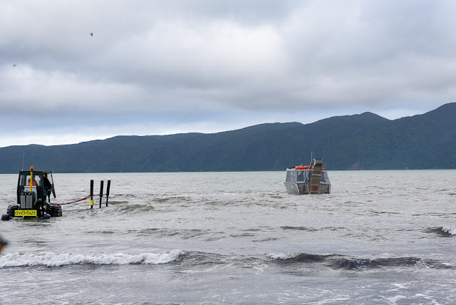
Private boat ramps on Waiorua Bay, Kapiti Island.  Photo: RGH


Driving to and from Wellington along the Kapiti Coast, when looking seaward the horizon is dominated by a large island. Kapiti Island sits just far enough offshore to appear perpetually verdant, mysterious, and unoccupied. Always looking for new places to explore, Kari discovered that it is an ecological reserve and is accessible for day trips and overnight stays. The island boasts an abundance of native plants and endemic birds, including the elusive Little Spotted Kiwi. It is one of the few places in New Zealand where one has a good chance of spotting a Kiwi (bird) in its native habitat. During our previous year here, Kari wanted to venture across Rau O Te Rangi channel and visit the island, but it was only after returning here permanently a few months ago that we were finally able to do so.

The island covers almost 20 sq km (8 sq mi), only a tiny portion of which is accessible for tramping. Almost the entirety is closed to the casual visitor and is set aside as a wildlife sanctuary. There is a limit to the number of visitors each day (100 to Rangatira, 60 to the North end). Interestingly, 13 hectares (32 acres) is privately owned by members of the Ngati Toa, Te Āti Awa, and Ngāti Raukawa Confederation. Many of them are whanau descended from an extraordinary woman, Utauta Webber, who refused to give up her land despite relentless government pressure to do so. One hundred twenty-one years after the Kapiti Island Reserve Act was established, whanau continue to live and work on Kapiti.


Paraparaumu to Kapiti Island.  Photos: RGH


John Barrett and Amo Barrett, Utauta Webber's grandchildren, established Kapiti Island Nature Tours by renovating the family bach and offering a unique homestay to visitors. Manaaki Barrett, John’s son and our host/guide for the weekend, grew up visiting the island and is now slowly assuming more responsibility for the daily operations of the business. It is truly a whanau affair, structured so that as many whanau as possible can be sustainably employed and maintain ties to their ancestral lands. Maori was not initially a written language and their history was kept alive through oral story-telling. We were captivated by Manaaki’s ability to narrate the history of his whanau and iwi, and deftly weave it into their story today.


Kapiti Island Nature Tours.  Photos: RGH & KAH


Utauta’s great grandfather, Te Rangihiroa, accompanied Te Rauparaha when Ngati Toa first seized the island in the 1820s. They successfully defended their occupation in the Battle of Waiorua (1824) when multiple iwi allied against them and tried to push them off. For Ngati Toa, Kapiti Island became a fortress and base from which to trade and launch marauding attacks. Ngati Toa developed trading relationships with whalers and fishermen from Europe and the Americas, encouraging them to live amongst them and accept Maori custom. Some married Maori women and were adopted into the tribe. As their cultures clashed, strife occasionally devolved into violence. In his book Kapiti, Chris Maclean describes Kapiti in the 1830s as “a wild frontier, a meeting point of two cultures without the restraints of law or government.” By the 1830s, the British had begun to establish a more consistent presence in the region, first sending HMS Zebra in 1833, then HMS Rattlesnack in 1838. The Treaty of Waitangi (1840) established British sovereignty in New Zealand and coincided with the decline of whaling in and around Kapiti. Whaling gave way to farming as a way of life, which only hastened the loss of native species.


Tramping through the nature reserve.  Photos: RGH & KAH


Tuteremoana summit and Western cliffs overlook.  Photos: KAH


Like much of the world, New Zealand has suffered the scourge of introduced species. Prior to the capture of Kapiti Island by Ngati Toa, the human impact would have been limited to subsistence living, supported by the abundant marine life and bird species, bouyed by limited cultivation of kumara. After their occupation, the population swelled to over 1000 people and new areas were cleared for food crops. The easiest way to clear land was by burning. Occasionally, controlled burns became wildfires that swept the island. New Zealand plants and birds evolved in relative isolation, free from predators and grazing mammals. Cattle, goats, sheep, and possum were introduced by European visitors to the island, and pests such as stoats and rats established substantial colonies. The introduction of these species proved devastating. When the island became a reserve in 1897, native plants and bird populations were finally able to begin a slow regeneration.


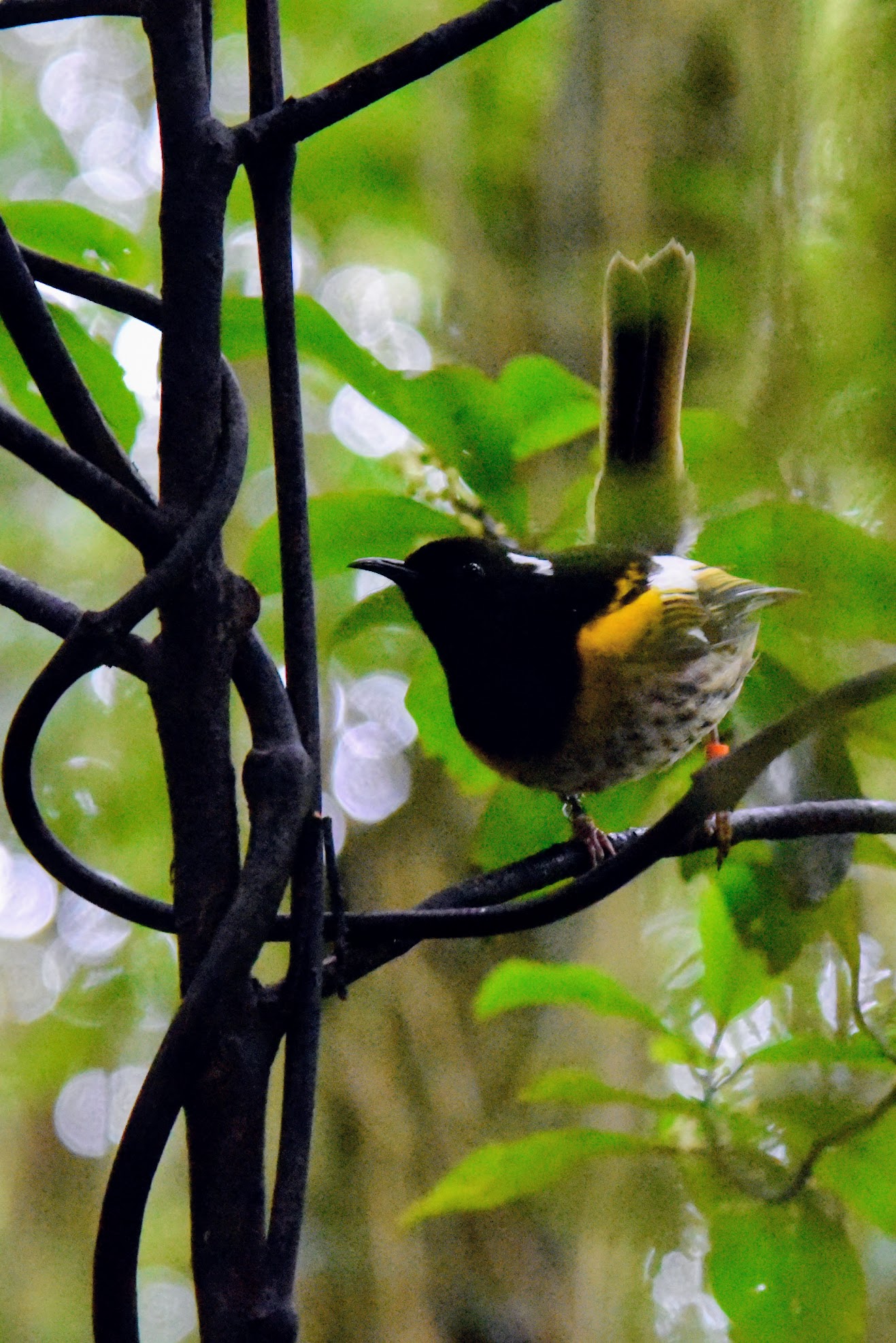
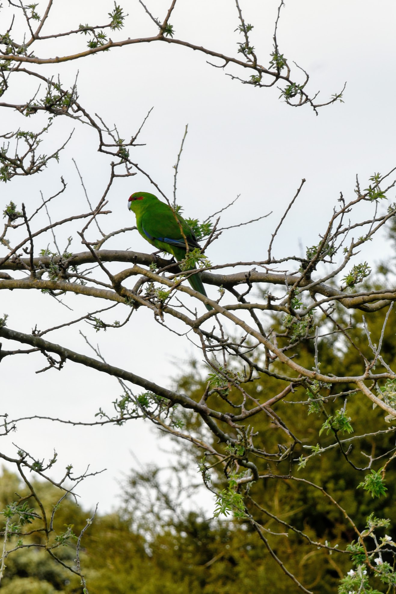
Hihi & Kakariki.  Photos: KAH

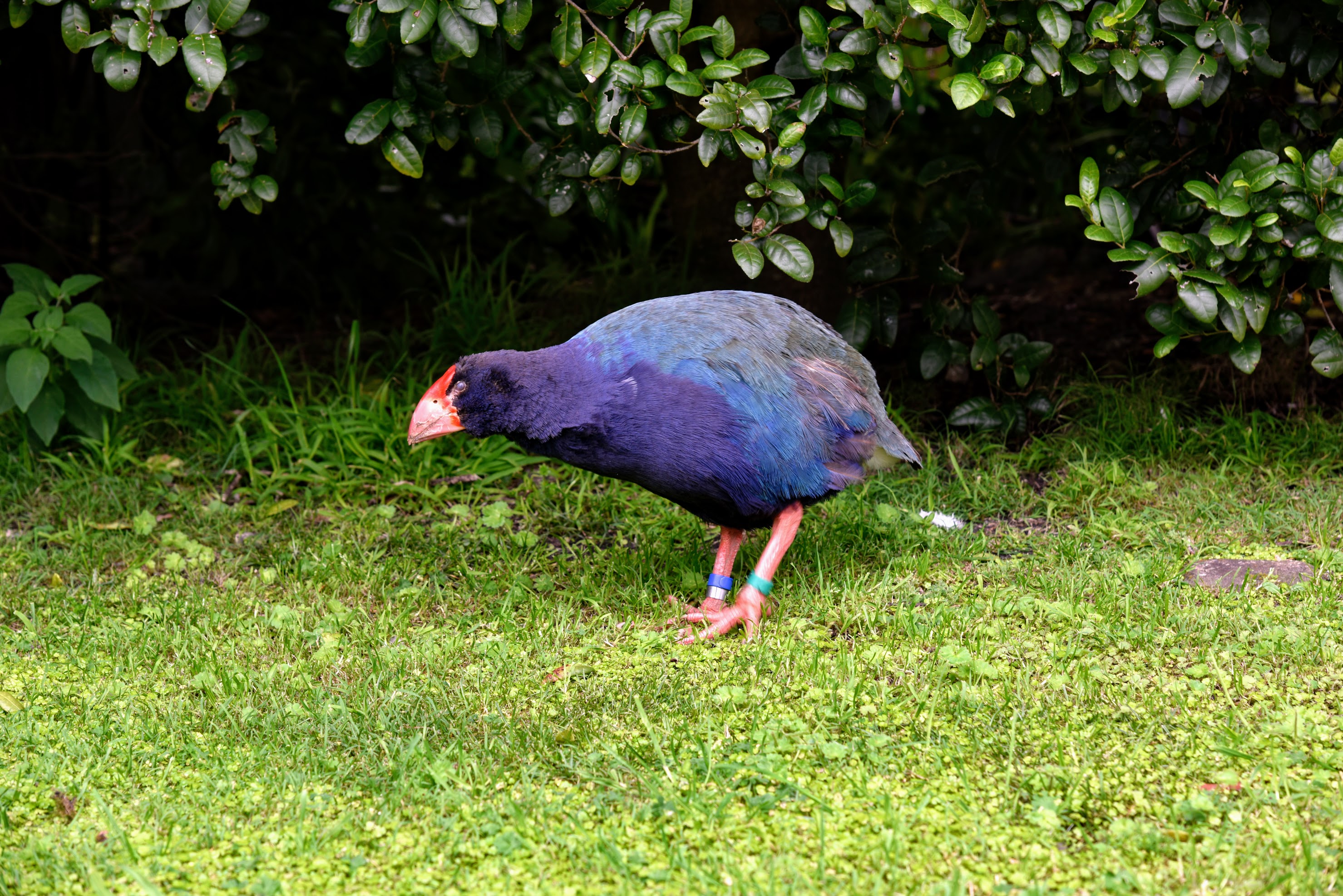
Takahe.  Photo: KAH

Kereru.   Photo: KAH

  
Kaka.   Photos: RGH


By 1917, a campaign to clear the island of grazing mammals and predatory pests had begun, but  limited farming continued on the island into the 1950s. It would take almost 80 years before the last rat, and last mammalian pest, would be cleared from the island and endemic species could flourish. Visiting the island today, it is the abundance and variety of native birds that are most impressive. Supported by the regeneration of native plant species, some have rebounded from in-place populations, while others have had to be re-introduced. This concerted effort to restore native bird species, with Kapiti Island acting as a “life raft”, has been so successful that some are transplanted from the island to bolster or re-establish populations elsewhere in New Zealand.


Sunrise over Waiorua Bay.   Photo: RGH

Manuka & view of Northern shore from Western cliffs.  Photos: KAH


Kapiti Island is one of the few areas where you might chance to see a Kiwi bird in the wild. "Might chance" is a bit of a misnomer ... we set out late at night with Wayne, one of the year-round residents, in search of these hard-to-find birds. Kapiti Island is far enough from the mainland that there is little light pollution, and it was a cloudy, nearly moonless night. More than once, I bumped into the person in front of me when they stopped abruptly. Using a light shrouded with red cellophane, Wayne crawled around on his belly looking into the dense underbrush. There were 13 of us split into two groups, and ours was the only one to actually spy a Little Spotted Kiwi in the bush. Admittedly, it was a bit anti-climactic, but it was pretty awesome none-the-less.


One of New Zealand's many great small breweries.


The next morning, the skies were clear and the sun was shining. We opted to take the afternoon boat back across Rau O Te Rangi channel, giving us a chance for a morning tramp to the top of the Western cliffs. After lunch, we set out on a guided tour of the Northern shoreline and bird nesting area. We thought we would be a little late getting to the boat landing, but were there in plenty of time to sit for a spell. Once across to the mainland, we stopped to slake our thirst and eat our fill of pizza at the Tuatara Brewery, then it was on to home.


Rats ...


28 September 2017

Castles in the Sky


Fair fa' your honest, sonsie face,
Great chieftain o the puddin'-race!
Aboon them a' ye tak your place,
Painch, tripe, or thairm:
Weel are ye worthy o' a grace
As lang's my arm.
- Robert Burns, Address to a Haggis


Doune Castle. Monty Python fans, if you don't recognize this place, I shall taunt you a second time. Photo KAH


It's almost a cliche, but our tour of Scotland has been defined by castles.

We left London on an early train to Edinburgh. It was a clear, sunny day in England, so of course we were leaving. I was excited to have a stop in Rugby, birthplace of the only game that matters (Link: Give Blood, Play Rugby), though we weren't there long enough to disembark. We had a brief lay-over in Preston, then it was on to Scotland. Watching the countryside roll by through the windows, the scenery was so much like New Zealand that we felt instantly at home. In Preston, we were joined by a boisterous group of Scots returning from holiday. As we got deeper into Scotland, the sky got more grey and dreary, and the Scots’ accents got thicker. We knew we were close to Edinburgh when we heard English language words but couldn't understand a thing they were saying.

Edinburgh is the end of the European portion of our travels. It is also very near to Stirling, home of a good friend. Tip and I played rugby together in Galveston TX, drank together almost everywhere, and even lived together for about a year when I first got into med school and had no money and nowhere to live. When I was racing triathlons, it was Tip who became my training partner, my coach, and who showed me how to win races. He left the US 14 years ago, chasing opportunities first in Birmingham (England), and now in Stirling. He had to be in Cologne on the day we would arrive to Edinburgh, so we made plans to spend our last few days with him on his return. But first, we needed a place to stay for one night in Edinburgh.


Rugby and Preston stations. Photos RGH


Throughout our trip, Kari did her usual amazing job finding us cool, unique, and fun places to stay. Our accommodations have included a traditional Japanese ryokan, a classic Dutch canal-side 3rd floor apartment, a street level apartment in a gritty area of Berlin, a Monastery in Prague, a funky modern hotel in Munich, and perfect apartments in the heart of it all in both Lyon and Paris. Each place has been in an interesting neighbourhood convenient for exploring the cities we visited. Having an apartment has given us room to spread out, kitchen facilities for preparing breakfast and snacks, and a way to experience our trip as locals might. It has invariably been cheaper than staying in hotels. Knowing we would be in Scotland, though, I wanted to stay in a castle. Kari set about looking for a castle-stay, but even 2-3 months out, everything was booked. She put us on some waiting lists and we hoped. She finally found a room at Dalhousie Castle, a place way more posh than we were hoping for. She also booked dinner in their dungeon restaurant.

Simon of Ramsay constructed the first castle at Dalwolsey, overlooking the River Esk, some time after 1140. The current construction dates to the 17th century. The castle has quite a distinguished history. King Edward I (Longshanks) stayed there en route to fight Sir William Wallace (more on him later) at the Battle of Falkirk in 1298. In 1400, Sir Alexander Ramsay withstood a 6 month siege at Dalhousie by King Henry IV. At the time of its sale in 1977, Dalhousie Castle had been retained by the same family for over 800 years, longer than any other castle in Scotland. On 27 Sept 2017, in our minds, it became a little more famous ...


Dalhousie Castle, Bonnyrigg. Photos RGH

  
Dinner in the dungeon was amazing. Photos RGH/KAH

  
In the evening, we retired to the library for drinks. Photos RGH/KAH


Unfortunately, we did not have time for the sport of kings. Photos RGH


Edinburgh Castle sits high atop Castle Rock, overlooking the city. The exact dates during which a fortified site was first established there is unclear, however there is evidence of continuous human habitation at the site since at least the 2nd century. There has been a royal castle on the rock since the 12th century and it was one of the most important Scottish strongholds through the Wars of Scottish Independence (1296-1357) and the Jacobite uprising (1745). It lays claim to the title of "The most besieged place in Great Britain" having withstood 26 sieges in its 1100 year-old history. Many of the sites we have been to have had self-guided audio tours, either free or for a nominal fee. Edinburgh Castle was no exception. We have really been impressed with the quality of the tours and information therein. We wanted to do a whisky tasting before leaving Edinburgh, but the day was drawing late and we still had a train ride to Stirling ahead of us.


Edinburgh Castle. Photos RGH/KAH


On 11 September 1297, the forces of Andrew Moray and William Wallace defeated a much larger English force on the banks of the River Forth, near Stirling. It was a battle that showed infantry can defeat cavalry (in certain circumstances) and was a turning point in the Wars for Scottish Independence. As Tip explained it, "Moray died of his wounds, and William Wallace lived. That's why Wallace is famous and Moray is not." Wallace went on to lead a destructive raid into England, and in 1298 was declared the Guardian of Scotland until he was defeated that same year at the Battle of Falkirk. He was betrayed, captured, hanged, drawn, and quartered in 1305 (despite what Hollywood would have you believe ... Freedom!) and his tarred head was placed on a pike on London Bridge. The Wallace Monument sits on the promontory from which he led his offensive, and Stirling Castle sits on the ridge opposite. Today, the fields between these sites feature an extensive rugby facility where battles of a different sort are waged.

Tip welcomed us to Stirling, then took us to his local pub for Scottish beer and a pub dinner. The next day, he showed us the campus of Stirling University, took us to Doune Castle, and drove us through several towns and villages. We ended the day with a wee hike to the Atlantic Wall and the Wallace Stones. Along the way, he regaled us with tales of the Picts, the Gaels, and the Scots. He spoke of historic battles and the Jacobite conspiracies. His intimate knowledge of the places, names, and dates was impressive. Tip and I had one last ramble in the muirs early the next morning. The wind was blowing hard, the sky dark and lowering, and the tall grasses moved like waves. It was about as perfect a Scottish experience as I could have imagined ... except maybe if I had been wearing a great kilt (though it would have been a wee bit drafty).


Stirling Bridge. Photos RGH

  
Making Monty Python proud at Doune Castle. Photos RGH/KAH

  
Village views. Photos RGH

Tip and his dog Riever in their native habitat. Photos RGH


This is the end for our tour of the unfamiliar. Everywhere we have been up to this point has been new to us, with new adventures, and new experiences. As I sit and write this post, we are winging our way across the Atlantic Ocean on our way to to the US. We will have two days in NYC, then continue to visit with old friends as we make our way down the east coast, and eventually return to Myrtle Beach. We have certainly enjoyed the ride.


Watch out for hairy coos ...