I cross the Green Mountain
I sit by the stream
Heaven blazing in my head
I dreamed a monstrous dream
Something came up
Out of the sea
Swept through the land
Of the rich and the free
- Bob Dylan
For this post, Kari did most of the writing. Like a good sports-casting team, she provides the colour commentary to my play-by-play. Enjoy the ride (it's a long one) ...

Mt Ruapehu
I've always been drawn to the mountains. That's a little odd ... I grew up around water, spending my days swimming, canoeing, kayaking. At 9 or 10 years-old, my first taste of freedom was being allowed to take the fishing boat, then the ski-boat, out on the lake by myself. I first saw the Rocky Mountains when I was about 16 or 17 and I have been running to the highlands ever since. The grandeur, the solitude, and an environment beautiful yet harsh and unforgiving to mistakes, lures me. I finally saw the desert when I was 23. In its ruthless landscape, I saw the same stark beauty. One of the most amazing nights I ever spent was out in the open under a clear desert sky. I had walked alone into the Mojave Desert to watch the sunset against the walls of Death Valley and decided to stay the night (#ThingsINeverToldMyMother"). I have spent most of my adult life living near water and tramping/climbing through mountains and deserts.
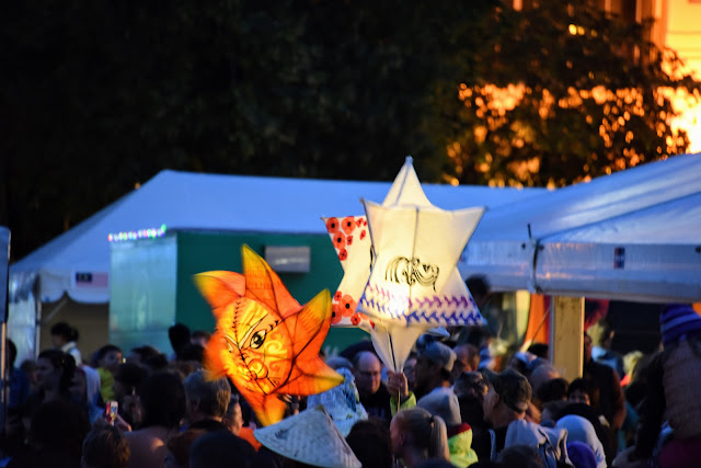
Minus the solitude, our day spent on the Tongariro Alpine Crossing was the perfect combination of mountains and desert. Taking 7-9 hours, the crossing is New Zealand's most popular 1-day tramp. In 2015 there were over 109 thousand hikers who made the crossing. DOC states that the trail has a capacity of about 600 people per day, beyond which the experience suffers. In 2015, 55% of the days had 600+ visitors, and each of the 3 busiest days saw >2000 hikers. It's a rugged and challenging hike, but for better or worse you are never alone. One of the photography websites I frequent said to get over trying to get a picture without people ... get used to it, incorporate them, and move on.


The trail was busy but not particularly crowded
Kari ...
I have spent most of my life "outdoors", whether it was water or land based, my late father and mother made sure my brother and I experienced and appreciated nature. Naturally, when Grant and I met, I was excited to continue the adventure with him and Little H, although my overall experience with hiking and camping was not as extensive as what Grant has accomplished. We had decided that our time in New Zealand was to be used to continue our outdoor adventures and experience all that this wonderful country has to offer.

Grant began researching the Crossing and organized what we needed, especially items necessary in sudden changes in weather. I did what I do ... found a place to stay and somewhere to eat. After speaking with several people in Palmy that have completed the Crossing, a common theme was evolving; long, hard, tough, bitch, Devil's Staircase, suffering, crippled, out of breath, plenty of water, windy, and so on. The best indicators were the facial expressions and moments of silence during each person's recollection of their journey on the Crossing.
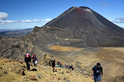
Gifted to New Zealand by Te Heuheu Tukino IV in 1887, Tongariro (est 1894) was New Zealand's first national park. It was only the 4th national park in the world at the time, and the first to be gifted to a nation by its indigenous people. The park covers 796 sqkm (307 sqmi) and encompasses the massifs of the North Island's three active volcanoes: Ruapehu, Ngauruhoe, and Tongariro. At 2797m, Ruapehu is the North Island's highest point, and while Ngauruhoe is technically taller than Tongariro, it's actually one of Tongariro's vents. It's important to note that these are active volcanoes. Ngauruhoe most recently erupted in 1974 with increased activity (though no eruption) in 2006 and again in 2015. The Te Mari craters on Tongariro erupted in 2012, sending blocks as large as 1 metre up to 2 km from the vent. The ash cloud reached 6 km and travelled 250 km in four hours.
Even though we were climbing Tongariro, and the park is named after this mountain, Ngauruhoe was the visually dominating feature. It was used as the inspiration for Mt Doom in the Lord of The Rings movies and portions were filmed on its slopes. The Maori hold the mountain to be tapu (sacred) so the summit itself was not filmed.


Ngauruhoe / Mt Doom
The typical route for hiking the Tongariro Alpine Crossing starts at Mangatepopo car park and finishes at Ketetahi car park. This route starts at 1150 m, ascends from 1400 m to 1600 m up the Devil's Staircase, crosses the Southern Crater, and peaks at the Red Crater summit (1886 m). At that point, you have only made it 8 km and have another 11 km to go. Fortunately, you are about half-way by time. The rest of the hike is primarily downhill but includes the most treacherous section.


Climbing the Devil's Staircase
Kari ...
The morning of the hike we were on time and had a few minutes to spare waiting for the one-way shuttle to drop us at the trail-head. This was a huge feat, given the early start and the fact that we are almost always late. I had prepared breakfast sandwiches to eat en route so that we were well prepared to start this journey. We would later find out that Little H had not eaten her sandwich and her hangriness tormented us for the first few hours. The level at which she was being unreasonable should have alerted us long before she confessed.
By the time we arrived to the Devil's Staircase, we were way behind schedule. Well, what we thought should have been our schedule. Yes, we were behind in time, but in retrospect there is no way we would have been able to complete the hike in our predicted 7-hour goal. You could follow the line of "ants" up the side of the mountain until they disappeared. I was a bit deflated mentally before we even started this section of the hike, so I took it in strides and stopped when I became winded, only resting long enough to get my heart rate down. I wasn't alone in this approach. As I looked around in front and behind me, our good friend and landlord's words kept echoing in my tired mind, "It's okay. When you are on the Devil's Staircase, at least you can look around and see everyone else suffering with you." The cruel fact about the Devil's Staircase is that you never really see the "end" due to the ascent; but once you reach the summit, you can put that bitch behind you, absorb your accomplishment and let those endorphins ramp you up for the next beast. And, remember, a scant tear shed is strictly a happy tear.


On a clear day, you can see Taranaki 136 km / 85 mi to the West
Kari ...
The flat, desert-like expanse of the South crater was my new BFF. We had conquered the Staircase, Little Highstead had eaten and shed her demon personality, and my thighs were praising Jesus. We were all smiles, soaking in the terrain and Mt. Doom, and laughing at all the crazies who decided to take the side hike up to Ngauruhoe summit. You could see them scaling the mountain. The ascent is 1 1/2 hours, with a 30 min descent. Um, yeah, because you are basically sliding or rolling down. No thanks. No need for me to attempt that side trip. As we approached the ridge between South Crater and Red Crater, it was easy to see the terrain was going to be the next bitch. In stark contrast to the much appreciated flat land under my feet, the ridge was scattered with volcanic rock and lacked the steps that the Staircase graciously awarded. I walked, crawled (yes, on all fours at some spots), and jumped my way to the top of the ridge. It was freakishly windy on the ridge; so much so that I could understand how someone, having ventured too close to the edge, could have been blown off the side of the ridge. I had already accepted that one must be creative in their conquering of this hike, seeing how the terrain is schizo and keeps you on your toes, or knees, or butt ...


Looking back across the South Crater

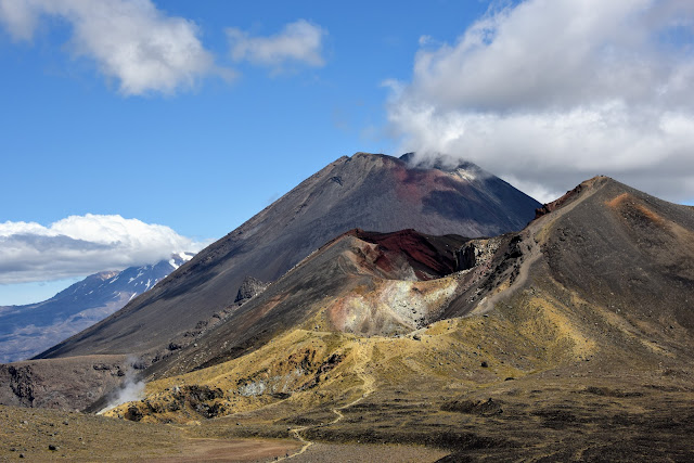
Rim of Red Crater with Red Crater summit in background

Red Crater
Kari ...
At the top of the ridge I rejoiced and even had someone take a picture of me. Yes, some stranger took the pic since I was literally in Grant and Little Highstead's dust most of the hike. No worries, this was about my completion of the journey. This area was a popular site for lunch and snacks, or to catch your breath. There were easily 100 people scattered about, with double that amount passing by and on to the summit of the Red Crater ridge. To reach the summit, you walk, crawl, or run up a steep but narrow path. At the summit I caught my breath and did a 360 to soak in this beautiful landscape. Is it just me, or does the Red Crater look like labia?!? I digress ... At 1886 metres, this was the highest section of the hike. Another challenge tackled ... and then I looked down at the scree field leading to the Emerald Lakes.


I admit it, I was angry at Grant for some of the photos he took. I mean, damn, how much less photogenic can you get breathless, sweaty, tachycardic and carrying a loaded pack nearly zip tied to your torso? I am ever so grateful he did not pull out the "real camera" and chronicle my descent down the scree field. Several groups around me had decided it would be a wise decision to hold hands, in some sort of supportive gesture, as they attempted to tackle this sketchy descent to beloved flat ground. No disrespect, but the only word that I kept uttering to myself was "Fools! If one of you dominoes goes down, it's all over but the crying." I conquered the descent with a cocktail of smooth moves that were a marriage of hops, steps, slides, sashays, and stances you would assume on a surfboard, because the terrain moved like water under foot. Let's just say I used muscles that have been dormant since birth. Nevertheless, I made it to the bottom without falling and quickly found my resting spot with Grant and Little H.
Lunch stop was at the Emerald Lakes. This is supposed to the the halfway point, timewise. I sat there and just let that sink in. I removed my hiking boots and socks, poured the kilo of scree out of the boots, and gazed delightfully at my blisters and dirt rings. Lunch was our typical hiking fare of salami, hard cheese, tortilla and fruit; however, my appetite was satiated at the moment from a combo of heat, dehydration, fatigue, and those celebratory endorphins. Oh hell, let's just be positive and blame it on the endorphins.
Descending from the Red Crater summit to the Emerald Lakes involves a slip-slide down a narrow ridge of scree. The dirt is loose, carpeted in sharp rocks, and has a steep drop-off on either side. When the scree field is crowded, it can be quite disconcerting. The views from the bottom, however, are unrivaled.
The Emerald Lakes are water-filled explosion craters. Blue Lake is a 16 m deep lava vent. The lakes are acidic (pH 3-5) and get their colour from dissolved minerals; green from colloidal sulphur and ferrous salts, orange from antimony, purple from manganese oxide, yellow from sulphur, and red from iron oxide. They are considered tapu ... touching the waters, dipping your feet, swimming, or even throwing rocks are all forbidden.


Blue Lake, Emerald Lakes, and the scree descent
Kari ...
While proud and thankful we had accomplished the first half of the Crossing, Mt Doom wouldn't take his eyes off me. Knowing that, I too was feeling a bit of doom. After our lunch break, the next hour or so was pretty much uneventful in terms of the real struggle. The scenery was anything but uneventful and the relatively flat terrain was a welcomed ally, sans a few shady volcanic rocks just large enough to roll an ankle.
We crossed the Central Crater with Tongariro to our left and Blue Lake in front of us. We had a short ascent to the shores of Blue Lake and circled to the north. Looking back across the Central Crater, clouds were starting to form on the mountain peaks but we had one last view of Ngauruhoe framed by Ruapehu and the Red Crater. As we stood on the northeast flank of Tongariro, our route ahead was a thin tan line zig-zagging down the mountainside and culminating in front of Lake Rotairo far below.
Ruapehu, Ngauruhoe, and the Red Crater. The broad grey line descending from the peak on the right is the scree field.


The little white squiggle down in the valley is where our car was parked
Kari ..
We reached a lookout point that shamelessly teased us with the sight of the very road our car was parked on. So close, yet so damned far ... and I would learn just how far over the next 3 1/2 to 4 hours. A quick glance over my shoulder and Mt. Doom was sneering at me, knowing he got the last laugh. I would later learn just what a cruel and ruthless giant he is.
As we made the descent to the car park, it felt as if we were chasing a mirage. I admit it, I became bitchy and snippy. I was mentally and physically spent. My knees, toes, quads and thighs were begging for mercy. Surprisingly, I looked forward to the few, random ascents during the walk down. I remarked to Grant that I was concerned about injuring myself due to how fatigued my legs were. I guess this is when walking poles would've come in handy. Damn! Should have taken our neighbor up on her loaner pair. I made a conscious effort to slow down. The last thing I wanted was to injure myself and hobble down in an even more crippled state than I already was.
"Where is the end of this damned track!" This became my silent and vocal mantra. I didn't care who heard me. I didn't care about much except finishing the walk. Along the way, there are general track signs with length and times posted to either encourage or deflate you, the choice is up to you I guess. Regardless, whoever estimates the time to complete the stated length of the trail have to be superhuman or drunk to come up with the times.
The end of the trail was so close I could taste it. I felt like a selfish child, thinking only of myself and putting a nail in the coffin of this journey. So much so that the last couple of hours I didn't pay Nature her due respect. I just wanted to be done ... a finish line that my mind and body had crossed hours prior. I was walking alone at this point, thankful Grant and Little H didn't have to witness my foul nature, but embarrassed that the passers-by and Mother Nature had to absorb my moment of weakness. I could hear faint cheering in the distance, but couldn't make out the words. As I neared the last few metres of the trail, I was the proud recipient of finish line kudos by strangers that had completed that same journey. I have to say, this brought a smile to my face, something that had been a ghost over the last several hours. Anyone who knows me well could attest to my outlook, personality and general mood. I am a smiler. I was grateful to have one back on my sweaty, grimy, beet red face. The cheerleaders were just waiting on their transfer bus, so a temporary celebratory squad, but I believe this should be a permanent fixture at the end of the Tongariro Crossing. Each individual deserves it.
Once in the car, I didn't take off my hiking boots. I already envisioned a ground meat appearance of what used to be my feet and toes. Besides, I needed my shoes on to collect my celebratory Coca-Cola at the first gas station or dairy we came to. I don't drink many sodas (called "fizzies" here), but I had decided that if I survived the Crossing, then that was my dirty little reward.
That evening, we drove into Taupo, had an incredible dinner at a bistro, and after wine and beer, I slept like a baby. In the morning, I was thankful I didn't have my usual nocturnal trip to the toilet. That would have guaranteed a face-plant.
So, the dramatization and sarcasm that are part of my daily life are reflected in my memories of the Crossing. Would I do it again? Probably ... don't tell Grant. Would I do things differently? Hell yeah. A few tips that I shamelessly will keep using are to covertly disguise air hunger and fatigue by:
1) tying shoes, doesn't matter who's ... mine, Little Highstead's, fellow trail mates, whatever ...
2) Take a picture ... or tons of pictures. Don't even pretend you don't know how many pictures I took and posted to Facebook.
3) Adjustments - straps, bra, underwear, hat, anything that potentially could be adjusted. Don't be too proud to help others, too.
4) Converse with other trail mates. Again, everyone knows what a talker I am and that I never meet a stranger. Now, these conversations may only consist of a "Hiya" (Kiwi for 'Hi, how are ya?' Sandwiched into one word) because you are so short of breath that is all you can muster.
5) Last resort is to say "Screw it" (or what every expletive you prefer. I often use a different four-lettered word to start the phrase) and tell your loving husband and daughter that you have eaten enough of their dust and damn it, you are stopping to catch your breath.
I am so thankful and proud to have completed the Tongariro Alpine Crossing. Next up, the Queen Charlotte Track. It truly is amazing to push yourself and complete those things that seem impossible. Cheers!

Good as gold!